Tasmanian Government Submission
Tamar Lake Feasibility Report
Overview
November 2024
Introduction
This page presents a summary of the science, engineering, economics, and environmental considerations and benefits for the transformative Tamar Lake project. Within each section there are links providing the opportunity for downloading all the reports carried out in exploration of the project’s feasibility.
After 14 years of intensive research, the private investment of over $800K into consultant studies, and hundreds of man-days of in-kind contributions by members and consultants, the not-for-profit, member funded, Tamar Lake Inc. (TLI) is very pleased to deliver to the Tasmanian Government this Feasibility Study overview and all the reports commissioned to enlighten the content of the Feasibility Report.
Key Finding:
The Tamar Lake project is a transformative project that provides the community with a substantial reduction in sediment deposits in the Upper Reaches, reduced flood risk and protection against sea level rise in the Launceston area, while also providing the stimulus for huge economic benefits through an almost unlimited supply of freshwater for the industrial area of Bell Bay and greatly improved water quality, aesthetic presentation and aquatic amenity of the Tamar at Launceston for tourists and residents.
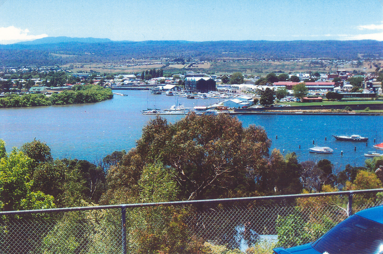 Home Point with freshwater flowing one way downstream This is what a Tamar Lake would look like
Principal Goals of the Tamar Lake project
The principal goals of the Tamar Lake project were to investigate a solution to the forecast catastrophic flood events in Launceston, and the continued buildup of sediment in the Upper Reaches of the Tamar that is greatly restricting aquatic amenity and reducing the aesthetic presentation of the Tamar around Launceston.
Sediment Accumulation in the Upper Reaches – cause and solution
Cause
Previous studies, carried out for the local Authorities over the last 50 years, had identified that the accumulation of silt flowing into the Tamar from the South and North Esk catchments, is deposited in the flocculation zone between Tamar Island and Freshwater Point, then is “pumped” upstream to the Home Reach/Yacht Basin area by the asymmetrical tidal action, particularly in the summer periods of low flows down the South Esk.
All the studies carried out for the local Authorities have confirmed that new silt from the catchment is entering the Tamar at the average rate of 39,300 Tonnes (120,000 cubic metres) per annum.
Solution Concept
All the studies carried out by Authorities before 2010 were aimed at the management of silt that had already accumulated, but the Foster report of 1986, and the review of the Foster report by BMT WBM in 2009 also indicated that the installation of a barrage to form a freshwater lake that removed the asymmetric tide from the Upper Reaches and moves the flocculation zone beyond the barrage may provide a sedimentation solution but was not considered because of cost.
Tamar Lake Inc., when formed in 2010, determined it would explore the barrage option for sedimentation management with the concept of installing a barrage as close to the estuary entrance as possible and manage the release of the freshwater downstream on the ebb tide to limit the effects of flocculation in the abbreviated tidal estuary.
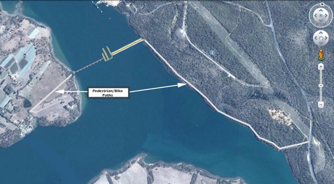
The location chosen for the barrage for the study was Point Rapid at the South end of Long Reach.
Preliminary Technical Assessment
The first study commissioned by TLI was for BMT WBM to undertake a preliminary technical assessment of the TLI concept including a first pass of the barrage and lake design.
The scope of the preliminary assessments reported are outlined in the points below:
- Changes to the hydrodynamic regime, upstream and downstream of the proposed barrage.
- Changes to the Water Quality regime, including qualitative assessments of:
- Changes to the flushing regime; and
- Changes to the nutrient cycle and potential for algal blooms.
- Changes to siltation regime, including qualitative assessments of:
- Potential for suspended sediment bypassing of the freshwater lake
- Likely zones of reduced/increased sediment deposition; and
- Likely downstream effects and the influence of discharge timing on sedimentation.
- Changes to the flooding regime, including qualitative assessments of flood mitigation potential of the scheme.
The key results from this study were that the Upper Reaches would become a net exporter of sediment and confirmed that, provided the freshwater is released on an ebb tide, the flocculation zone will be moved further downstream. How much further downstream before the sediment accumulates on the floor of the estuary will depend on the strength of the freshwater flows. Tamar Lake modelling assumed a water release twice per day on each ebb tide; but there is scope to model the effect of higher rates of flow with water releases far less frequently.
The studies also showed that over time, with each major flood event that tops the Trevallyn Dam, residual silt on the bed of Home Reach/Yacht Basin will be eroded downstream, never to return because of the removal of the asymmetric tide. Mechanical agitation in the form of raking could be used to increase the rate of erosion of this residual silt.
The report also indicated that further study on sedimentation of the Tamar would require a 3D model of the whole Tamar Estuary. At the time only a 2D model was available so effort was directed to arrange finance for the upgrading of the 2D model to a full 3D model of the whole Tamar Estuary with thermal stratification capabilities.
The full BMT WBM Technical report R.B18703.001.02.TamarLake.doc February 2012 is available Tamar Lake Technical Assessmet Final BMT WBM Report.
Sea Level Rise – Protection of the low-lying areas of Launceston
The Technical report indicated that the barrage design should protect the low-lying areas of Launceston against a Sea Level Rise of up to 0.8m but further study would be required to confirm this.
Flood Management
The Technical report indicated that management of the barrage flood gates could enable some level of flood mitigation for both current sea level and sea level rise conditions of up to 0.8m.
Using the TUFLOW model developed for the Launceston Flood Authority, TLI commissioned a report that looked at the following issues:
- Calculate the drawdown time of the lake from 0.9m AHD to 0m AHD.
- Undertake a flood impact assessment under a number of scenarios, namely:
- The barrage in place being operated to provide flood buffering; and
- The barrage in place with the gates fully closed (the worst-case scenario).
- The scenarios above were assessed for the 1 in 100 year and 1 in 200-year ARI events under both the current sea level conditions and a sea level rise assessment whereby sea levels were increased by 0.8m.
The full BMT WBM report PP: L.M20391.002.BarrageAssessment is available here L.M20391.003.BarrageAssessment and makes the point that the barrage gates should be designed to be fully fail safe to obviate the worst case scenario examined in the report. This was considered in the barrage design.
The studies concluded that with active management of the water level in the lake creating a 45 GL buffer and the removal of the incoming tides upstream, the peak level of all flood events from 5 year to 200-year events could be reduced by at least 1 metre.
Peer review of the BMT WBM report.
The TL environment consultant, Mark Breitfuss of Epic Environmental, suggested TL should have a peer review carried out on the BMT WBM flood report. This was done pro-bono by WREMA as shown in the report here .WREMA Flood modelling Peer Review.
Barrage Design and Costing
The Technical Assessment provided data on the barrage flood gate design necessary to ensure that the barrage would have no detrimental effect on flood levels further upstream to Launceston. In contrast, as shown in the Flood Report intelligent management of these flood gates will have a mitigating effect on flood levels in Launceston.
On receiving this TLI commissioned C D M Smith to carry out a more detailed design of the barrage and provide a cost estimate for the construction of the barrage at Point Rapid. C D M Smith were the consulting engineers for the design and construction of the Marina Barrage in Singapore in 2008 and so had excellent credentials to provide TLI with this estimate.
In 2012 the estimate was $320 million but more recently TLI has used a figure of $ 500 million for the construction. Estimated operating expenses were included in the KPMG Economic study carried out later.
The report from C D M Smith may be downloaded here Barrage Design and Costing
C D M Smith also provided TLI with a proposal for the detailed design of the barrage should the Tasmanian Government wish to proceed to implementation. This proposal is available here Tamar Barrage Costing proposal.
Sale of Freshwater to Melbourne
Stimulated by an introduction from one of our consultants, TLI received an unsolicited proposal from a French Company, Via Marina, for the provision of a freshwater pipeline from behind the barrage at Point Rapid to the desalination plant at Wonthaggi in Victoria to provide freshwater across Bass Strait for pumping into the Melbourne water supply system that is increasingly challenged to service the needs of a rapidly growing city. Our economic consultants, NERA, determined that at a consumption of less than 10% of the water flowing into Tamar Lake from the catchment, Tasmania could deliver the same volume of freshwater to Melbourne as the desalination plant at a fraction of the cost. The report from Via Marina is available for downloading here. Submarine River Tasmania to Victoria.
Environmental
It was clear from the Technical Assessment that the change in the ecology of a substantial portion of the Tamar Estuary to a freshwater lake would require a good understanding of the natural environment of the current river system, and a preliminary understanding of any potential threatened species and eco-system impacts in a Tamar Lake environment.
To achieve this at the feasibility level, TLI commissioned a very comprehensive assessment of all the natural values of the Tamar Estuary by Dr. Andrew Costen of BMT WBM in Melbourne and then followed this up with a commission to Dr. Mark Breitfuss of Epic Environmental to analyse the Costen report and to report on any threatened species and potential eco-system impacts of a Tamar Lake environment. Dr. Breitfuss also suggested a range of mitigation measures that could be taken to reduce the effect of changes to the eco-system and recommended that a full Environmental Impact Analysis (EIA) be carried out to more accurately understand the environmental effects before a decision is made to proceed to the planning stage.
The 160 page Natural Values Assessment by BMT WBM in 2012 is available for downloading here Natural Values Desktop Assessment – final.
The 35 page Breitfuss report on threatened species and eco-system impacts is available for downloading here. Ecological Assessment of Threatened Species.
Rice Grass Elimination
While there are a lot of questions that need to answered in a full EIA, there is consensus from these reports that the introduced pest Rice Grass, currently inhabiting over 400 hectares of the shoreline in the middle reaches of the estuary, will die off in the freshwater lake environment with a transitory effect on water quality downstream.
Extent of Rice Grass meadows
Peer Reviews by external consultants
On receipt of the above two reports, TLI sought peer reviews through NRM North.
Two reviews were received, one by an external consultant David Rissik which is available for downloading here, D Rissik Peer Review Report_Tamar Lake Proposal_Nov2014and the other from a staff scientist Dr Catherine Murdoch available here. Tamar Lake_Natural Values Report_ Env Comments .
Economic Studies
NERA economic study
In 2013, TLI commissioned the global economic consulting firm NERA to carry out a detailed study of the economic benefits for Northern Tasmania arising out of the formation of the proposed Tamar Lake.
Their study looked at the economic benefits of Tamar Lake from:
- Agricultural Irrigation – this was before the Tamar Valley Irrigation scheme was planned
- Sale of freshwater to Victoria via Via Marina submarine river
- Use of freshwater water for industrial processes at Bell Bay – with the current plans for hydrogen and ammonia production at Bell Bay requiring large volumes of freshwater, a similar study carried out today would show a much larger economic benefit from the Tamar Lake project.
- Fisheries – this study looked at both the positive and negative values including the probability of the closing of the Long Reach salmon farm.
- Residential and commercial property values
- Tourism
- Flood and sediment management – avoided costs.
The agricultural irrigation segment was carried out by the local firm Macquarie Franklin who had firsthand knowledge of the potential for cropping in the Tamar Valley.
The report conclusion showed a value-added benefit of $553 million, which if repeated today would show at least double this value add.
The full report is available for downloading here. NERA Final Report_10 April 2013 .
KPMG Economic Report
Following on from the NERA report, KPMG was engaged to assist TLI determine the high-level economic impacts of the proposal to install a barrage on the Tamar River.
This report aimed to build on the pre-feasibility study by NERA by quantifying the net economic benefits of the project using non-linear input output modelling techniques contained within the Tasmanian Non-Linear Model (TNLM). This modelling was undertaken by Professor John Mangan from the University of Queensland.
This report looked at:
- The capital costs and economic benefits of barrage construction, irrigation scheme construction, and irrigation scheme ‘connections’ by users.
- Operational costs and economic benefits of the barrage supplier’s irrigation scheme users
- Operational costs and economic benefits of barrage, irrigation scheme supplier
- Tourism expenditure impacts; and
- Fisheries expenditure forgone.
The modelling had some caveats, including the fact the project has been evaluated for over an 18-year period. Over this time there is the issue of economic structural changes, displacement, and capacity constraints.
The report forecast an increase of 3% in GRP over the 15 years post the start of barrage construction.
The full report is available for downloading here. KPMG – FINAL-TLI14-Tamar Lake Economic Impact Report-R3006 .
Tamar Estuary 3D hydrodynamic model
Up to this time, the only modelling facility for the whole Tamar Estuary was a 2D model developed previously for flood modelling in Launceston.
After a submission by Tamar Lake Inc. to the then Minister for Infrastructure, Rene Hidding, TLI was provided a grant of $75K towards the development of a 3D hydrodynamic model of the whole Tamar Estuary, which along with a similar $75K federal grant through the Chairman of the Launceston Flood Authority, Alan Birchmore, was directed to NRM North for the management of this development by BMT WBM.
This model was completed in late 2015 which then enabled TLI to carry out detailed modelling of sedimentation and water quality issues associated with the formation of the Tamar Lake.
3D Hydrodynamic Studies
In 2016/17 TLI Commissioned BMT WBM to model a range of Tamar Lake scenarios that looks at the effect of the formation of the Tamar Lake on sediment transport and water quality compared with the current tidal environment with the same input flows.
The specific scenario modelling carried out to date includes:
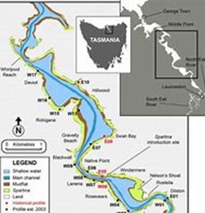
- The concentration of suspended sediments near the water surface and near the bed for the 17 TEER program water quality sites from Cataract Gorge to Low Head.
- Sediment accumulation for the 12 months July 2010 to June 2011 for two locations:
- The Home Reach section from the North Esk to Tamar Island
- The estuarine section from the barrage in Long Reach to Low Head
- Sediment accumulations for a 3-month dry period from January 2009 to March 2009 for the Home Reach section from the North Esk to Tamar Island
- Impact of the barrage on water levels downstream of the barrage
- A range of water quality scenarios for the 17 sites Cataract Gorge to Low Head comparing the current estuarine case against the proposed barrage case
- Estimate of the transfer time from a salt water estuarine system to a freshwater lake system after construction of the barrage
- Global Research on destratification systems for mitigating the risk of Algal Bloom
- Investigation of a range of destratification methods for reducing the risk of late summer algal blooms by controlling the release of reduced dissolved oxygen water through outlets at the base and top of the barrage.
- Investigation of the water quality in Zone 1 in a Tamar Lake environment versus the current estuarine environment.
These water quality studies not only considered the current water quality conditions in the Upper Reaches but also considered the effect of the planned Water Quality Improvement Plan (WQIP) developed by NRM North and the Launceston Sewerage Improvement Plan (LSIP) developed by TasWater.
We believe this is now covered under the River Health Action Plan.
The complete report by BMT WBM, M.B20921.008.Scenarios_Update.docx, is available for down loading Sedimentation and water quality – very final This should be read in conjunction with the following clarification. L.B20921.008.SedimentFluxesClarification.
The brief results are as follows:
Sedimentation
This report that looked only at sedimentation in the Upper Reaches and downstream the barrage (2,3) confirmed the previous findings that the Upper Reaches would be a net exporter of sediment (12-month simulation) and there would be negligible sediment accumulation in this area over a 3-month dry period due to the removal of the asymmetric tide.
Turbidity
Turbidity was examined over the whole length of the Tamar estuary with a very significant reduction in turbidity in the Upper Reaches around Launceston. The water in Home Reach would be as clear as the flowing through the First Basin.
Water Quality
The water quality studies focused specifically on WQ in zone 1 and in the area immediately upstream of the barrage.
The results for Zone 1 were:
- Water Quality – catchment sourced and normal STP discharges
The water quality in the Yacht Basin/Home Reach area will, within 12 months, be greatly improved with pollutants flowing one way downstream from the Tailrace instead of being “pumped” upstream into the Home Reach/Yacht basin area.With the removal of the asymmetrical tidal action from the Upper Reaches, 80% of all new pollutants entering the Tamar down the Tailrace, or from the sewage treatment plants at Ti Tree bend and Riverside flow one way downstream from the Tailrace. - Water Quality – Launceston’s Combined System Overflows
With the removal of the asymmetric tidal action, any Combined System Overflow (CSO) events from the current Launceston treatment plants will flush rapidly with the stormwater one way downstream instead of being locked into the Home Reach section.
A separate report for WQ in Zone1 is available for downloading here. R.B22148.002.01.Zone1WQ .
- Water Quality – upstream the barrage
As with any large body of constrained freshwater fed from a large rural and urban catchment area, Tamar Lake will have the potential for algal blooms to form on the surface of the lake during the warmer days of mid to late summer. The studies showed that this would be the case in a Tamar Lake environment which stimulated an extensive period of further studies into the cause and effects and possible methods of mitigation of the risk of algal blooms with some success. However, it became clear that this issue was beyond the feasibility stage and would need extensive study when a full EIA was carried out.
The extent and results of these destratification studies will not be covered here but the reports produced are available for detailed study.
R.B20921.002.00.Destratification_Investigation.docx, February 2016 is available here .R.B20921.002.00.Destratification_Investigation
R.B22148.001.03.DestratScenarios.docx, August 2017 is available here. R.B22148.001.03.DestratScenarios.
During the above studies the theoretical calibration numbers used in the Tamar Estuary model for the Nutrient Sediment Flux (NSF) parameters came into question and would greatly affect the results presented.
To get another specialist opinion on this, TLI commissioned a peer review of the work done to date by Dr Tony Church. He too queried the theoretical NSF parameters used by BMT WBM and recommended that actual measurements be made along the bed of the estuary and used in a re-run of the previous modelling. This was well beyond the scope of the TLI studies so no further work was done on this subject.
Dr Church’s report is available here. Tony Church Sedimentation and Water Quality review. .
Funding Studies
Value capture funding methods
Acknowledging the significant level of funding required to implement the project, Tamar Lake Inc. commissioned the global consulting firm AECOM in February 2017 to estimate the potential for value capture funding methods to contribute to the funding of the Tamar Lake project.
Value capture funding methods are a relatively new concept in Australia. Traditional approaches to funding methods for new or improved infrastructure have used funds entirely sourced out of general taxation revenue, meaning all taxpayers share the burden of paying for the infrastructure despite the fact that many of them will not use or directly benefit.
By identifying and quantifying the value created from the development of the new infrastructure, and connecting it with the costs of the infrastructure, value capture mechanisms can help deliver projects through a fairer business model.
AECOM conclusions
The report prepared for Tamar Lake Inc. by AECOM concluded:
Given the current indicated construction cost of $500 million, the benefits to property values alone from the project greatly exceed its costs:
- The uplift in median residential property values in Launceston, within 1km of the Tamar Lake shoreline, following construction of the Project and stabilisation of values is conservatively estimated to be $1 billion.
- The uplift in median unimproved commercial land values in the Launceston CBD within 500m of the riverfront following construction of the Project and stabilisation of values is estimated to be $434m.
AECOM identified the following potential value capture funding methodologies to be applied to the Tamar Lake project:
- Selling development rights and/or density above existing zoning controls.
- Sale of government-owned land that is enhanced or made developable by the project.
- Captured through public taxation system such as land tax, council rates and stamp
duty, and possibly captured through sharing value uplift with surrounding landowners.
The encouraging outputs from this AECOM study support further work being undertaken into the application of value capture funding to the Tamar Lake project. Tamar Lake Inc. would recommend this work be included in the broader socio-economic study that would be initiated as part of preparation of a formal business case for the development of the Tamar Lake project
The AECOM Report is available for downloading here. AECOM 20170830_Tamar Lake_Interim Working Paper_Submitted. .
Initial Feasibility Report submission to Government.
In 2017/18 Chairman Allan Garcia of TEMT sought input from the community on possible solutions to the sediment accumulations in the Upper Reaches of the Tamar. As all the reports referred to in this document would have been too large a submission, TLI summarised all the reports in a single Feasibility Report which is available here. Tamar Lake Feasibility Studies – Part 2 – Final Report
In the submission to Chairman Garcia, an offer was made to supply any or all of the complete reports referred to in the Summary report. This offer has not been accepted to date.
Sedimentation Studies – Long Term
When the TEMT Sedimentation study was released in 2021, concerns were expressed by members of the public about the potential for extensive sediment accumulations both upstream and downstream from the barrage in a Tamar Lake environment.
As the original sediment studies only looked at the sedimentation in the Upper Reaches (Zone 1) and immediately downstream the barrage over a 12-month period, TLI sought a proposal from BMT for a 50-year study of the fluvial sedimentation of the complete estuary including possible coarse marine sediment transport upstream from Bass Strait.
The brief to BMT included the projection of sedimentation over the long term for both the current tidal environment and the Tamar Lake environment.
The quoted cost of this study was $50K, of which $15K included permanent extensions to the stakeholder’s Tamar Estuary model to cover long term modelling and marine sediment transport up the estuary from Bass Strait.
With a contribution of $50K from TLI members, this report was commissioned to BMT and delivered in August 2022. On receipt, a copy of this report was delivered in good faith to the Chairman of TEMT, Gary Swain, for delivery to all TEMT members. No response or expression of gratitude has been received from the Chairman or any TEMT member.
The brief results of this study are as follows:
Sedimentation – North Esk – for the tidal case the North Esk will continue to infill up to regime equilibrium level, but in the Lake case the North Esk will be a net exporter of bed sediment particularly during flood events.
Sedimentation – Upper Reaches/lake – for the tidal case almost 100% of the fluvial silt input load of an average 120,000 m3/year is maintained in the Upper Reaches where it is mobilised and re-distributed upstream by the tidal regime. This contributes substantially to the increase in the extensive shallow and inter-tidal mudflats in the Upper Estuary.
For the Lake case the Upper Reaches will become a net exporter of sediment due to the erosion of sediment from the Yacht Basin and Home Reach driven by flood events. The on-going fluvial supply from the catchment and any sediment mobilised from Home Reach is predicted to disperse and settle in the relatively deep and wide areas of the lake from Stephenson’s Bend to Point Rapid. Sediment settling to the bed from the freshwater of the lake will tend to settle in the deep channels. The predicted sediment load retained in the lake of an average 86,000 m3/year is likely to result in an annual increase of sediment depth of only 1.8mm per year. At this rate it would take approximately 46 years for sedimentation to reduce 1% of the lake volume of 400GL.
Sedimentation – Downstream the barrage – the studies show that in the Lake case, only an average of 20% or 22,000 m3/year of the fluvial sediment flows through the barrage into the downstream area. This equates to only an average increase in sediment depth of 0.7mm/year in the area between the barrage and Low Head.
The studies also showed that during flood events, there is enhanced sedimentation just downstream the barrage in Long Reach due to the flocculation of silt-laden water discharged from the lake mixing with salt water. However, sedimentation rates predicted for the port facilities at Bell Bay and Inspection Head do not exceed 1mm/year which are unlikely to pose a serious constraint to Port operations.
Sand and fluvial sediment – Upstream from the estuary entrance at Low Head – In the tidal case there is significant sand transport upstream due to wave and tidal forcing from Bass Strait. With reduced tidal prism under the Lake scenario sand transport at Clarence Point is reduced from 1500 m3/year to just 110 m3/per year, and with the fluvial sediment load into the estuary of only 22,000 m3/year the estimated timescale for infilling of the lower estuary in order to approach regime equilibrium is likely to be of the order of 5,000 to 10,000 years.
Over this long timescale the lower estuary would be expected to evolve towards a more fluvial character than the existing tidal case.
The full Long Term Sedimentation Study is available for downloading here Long-Term Sedimentation Study – BMT R.A11690.001.01 and the following chart provides an overview of these results.
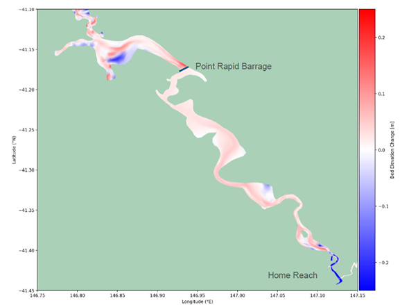
Tamar Sediment accumulation and erosion over a 10-year period in Tamar Lake scenario. |
Flood Mitigation Report
The original Tamar Lake flood modelling and barrage design carried out in 2014 used the flood flows determined in the 2008 BMT River Tamar & North Esk River Flood Study report and was for the purpose of insuring that the introduction of a barrage at Point Rapid would not have a detrimental effect on flood levels in Launceston.
In early 2024, TLI became aware of an updated 2018 Flood Modelling report (R.M.20921) carried out for the Launceston Council that the climate change driven increase in forecast rainfall, flood levels, and sea level rise collectively mean that Launceston’s levee system will no longer provide the desired level of Urban flood protection, not just in the long term but in the short term.
The report showed that if Northern Tasmania had a 1 in 200-year flood event next week, the current levee system at 5.1m AHD would be topped and Invermay and the other low-lying areas of Launceston will be flooded to a depth of at least 2 metres.
With a forecast of rainfall and sea level rise conditions out to 2090, the report showed that if Launceston had a 1 in 50-year flood event it would flood Invermay to a depth of 0.5 to 1.0 metres and a 1 in 200-year event would flood Invermay to a depth of 5m.
Recognising the consequences of this report and based on our previous experience in flood modelling TLI developed a Flood Mitigation proposition that was presented to Council by John Pitt. This gained unanimous support by the Council and has eventually led to the approval of the Council’s Flood Mitigation Strategy Scoping Study.
Also based on the TLI experience of flood mitigation with the dynamic operation of flood gates in a barrage situated at Point Rapid TLI recognised that a revised design of a barrage and operating parameters should be one of the options considered by Council for their flood mitigation program.
Based on this, TLI approached the BMT Flooding Team Leader located in Sydney for the preparation of a proposal that considers the barrage design and buffer operating options that have the potential to manage flooding in Launceston within the current levee system height and for the projected life of the barrage.
The proposal received by TLI in June 2024 would use a refined TUFLOW model that will be used to simulate:
- Existing design flood conditions for the 1%, 0.5% (1 in 200) and 0.2% (1 in 500) Annual
Exceedance Probability (AEP) design events under spring tide boundary conditions.
- Design flood conditions for the 1% AEP and 0.2% AEP design events under 2090 and 2150 Climate Change Scenarios assuming sea level rise.
All simulations will be carried out over 10 tidal cycles.
The Existing Scenario TUFLOW model will be updated to incorporate the proposed development works and used to simulate the “proposed” (or post-development) flood behavior. We assume the model updates will include:
Representation of the proposed Tamar Lake Concept assuming:
- Scenario 1 – An 800 m wide barrage at Point Rapid, with flood gates crest at –3 mAHD and weir crest at 2.2 mAHD assuming a drawn down of the lake to 0 mAHD prior to flood events.
- Scenario 2 – An 800 m wide barrage at Point Rapid, with flood gates crest at –3 mAHD and weir crest at 2.2 mAHD assuming a drawn down of the lake to -1 mAHD prior to flood events
- Scenario 3 – An 800 m wide barrage at Point Rapid, with flood gates crest at –3 mAHD and weir crest at 2.2 mAHD assuming a drawn down of the lake to -2 mAHD prior to flood events.
Scenario 3 lowers the level of the lake to approximately the current low tide level which of course currently occurs twice per day and would only be required for a projected catastrophic flood event.
In line with the scope provided by Tamar Lake Inc, each Scenario will be designed to cater for the 0.2% AEP flood event under 2090 Climate Change conditions. Up to 3 model iterations will be undertaken for each scenario to determine the required number of gates and the width of weir to comply with this design standard.
The modified model will then be used to simulate flood behavior for the events listed previously. We have allowed for assessment of the three design scenarios listed above as part of this proposal. Peak flood depths, levels and velocities will be extracted from the results and presented in a report.
It is the opinion of the TLI team that this report should be prepared as soon as possible to determine whether this is a possible solution for the long-term Launceston Flood Mitigation requirements.
The Choices
The decision by the community to implement the Tamar Lake proposal will probably be the toughest decision the State has ever had to make, but the choices are clear:
- Over the next 30 years spend up to $1 billion of taxpayer revenue, without any substantial direct boost to the economy, to slowly improve the water quality in the Upper Reaches by implementing TasWater’s Launceston Sewerage Improvement Plan (LSIP) and NRM North’s Water Quality Improvement Plan (WQIP) and the TEMT River Health Action Plan which will substantially reduce the CSO overflows but with continued infilling of Zone 1 with new sediment deposits and a poor aesthetic presentation of the river with muddy turbid tidal water to present to the next generation.
or - Implement the Tamar Lake plan in the short term for an investment of up to $500 million (of which 30 to 50 % could be privately funded), and provide the foundation for a huge short and long term boost to the economy in the tourism, agriculture, industrial and commercial sectors, with the formation of a freshwater, low pollution, low turbidity lake, with little new silt deposition over the length of the lake and the gradual erosion of residual silt and rice grass meadows over time.
Conclusion
In producing this report, the executive and members of Tamar Lake Inc. have invested their time and cash over 12 years, with no expectation of any return, in pursuit of a solution to what has been acknowledged by almost all residents of Launceston as a totally unacceptable situation.
This situation has been brought about by the initial siting of Launceston at the confluence of the Tamar and South and North Esk rivers; poor land management since European settlement by farmers and loggers in the catchments; watercourse width and depth reductions both by natural sediment infilling and the community’s infilling and bank modification of areas around Home Point and Royal Park; and to an antiquated sewage treatment and stormwater system that has not kept up to modern standards for effluent discharge and urban runoff.
With the release of this report, the altruistic investment by the members of Tamar Lake Inc. has been completed. This report will be made available to the Tasmanian Government for consideration in determining whether the investment should be made in the next stage of the planning and approvals process. If a State Authority is nominated or formed to manage all aspects of the Tamar Valley health and amenity, and funding is provided to that Authority to carry out the planning and approvals process, all the reports commissioned by Tamar Lake Inc. will be made available to the Authority at no cost to that body.
With the environmental, lifestyle and economic benefits that would accrue to the Northern Tasmanian community with the implementation of the Tamar Lake plan, there is no reason why all three major parties in the State Parliament would not support a proposal to fund the planning and approvals stage.