The following are the questions, with answers, that are most frequently asked when presenting the Tamar Lake concept to the community.
Click on the question and the answer will show.
Numerous Letters to the Examiner, and forums conducted by Tamar lake Inc., have asked the question why does the Tamar River need a barrage, what effect will it have, and why place it at Long Reach?
Without trying to cover all environmental and economic benefits covered in the recently released Feasibility Report (downloadable from www.tamarlake.com.au) these fundamental questions need to be addressed.
What is a barrage?
It is not a dam that floods the natural flora and fauna behind it.
A barrage is a special form of weir placed in a natural water course, but instead of a fixed crest, the Tamar Barrage has a series of gates that provides a variable crest height, and controlled relief downstream for flood waters flowing into the Tamar from the North and South Esk .
In the case of the Tamar barrage, it also has a ship lock that enables the passage of boats from the estuary upstream to Launceston with a 24/7 high tide level water depth.
Why a Tamar barrage?
All the silt studies carried out for the Launceston Council, since the original study by Foster in 1986, have confirmed that with normal and flood flows, the only form of silt to enter the Tamar is the fine particle clay silt from the South Esk through the PowerStation and Tailrace, and over the weir at St Leonards, with the coarse particle sands and gravels being trapped behind the man-made Trevallyn Dam and weir structures.
These same studies confirmed that the fine particle silts remained in suspension in freshwater until the salt concentration was of sufficient strength to cause a chemical process called flocculation to occur which forms floccs of mud with precipitation to the bed of the river. In the Tamar River, this process occurs principally between Tamar Island and Freshwater Point. The floccs of mud are then subsequently “pumped” back upstream and deposited in the quiescent areas of the Yacht Basin/Seaport/Home Reach area.
With the installation of a barrage to separate the saltwater tidal estuary from the freshwater flows, principally from the Esk Rivers, the silt flowing down these rivers remains in suspension in the freshwater behind the barrage, with the flocculation zone moved to downstream the barrage into the saltwater tidal estuary.
Why located in Long Reach?
There are many benefits for locating the barrage in Long Reach, just upstream of the Bell Bay Port, but sticking with the sedimentation subject, 3D hydrodynamic studies carried out for Tamar Lake Inc. showed that if the freshwater with silt in suspension is released through the gates in the barrage on an ebb tide, (i.e. when the lake level is higher than the tidal level) the freshwater layer is carried out to Bass Strait on top of the outgoing tidal water with the silt remaining in suspension with limited mixing with the saltwater, and hence limited flocculation, until it reaches Bass Strait.
This location also has a number of other significant benefits:
- Protection from sea level rise of up to 0.8 m for all the valley upstream of the barrage, but particularly the low-lying areas of Launceston.
- An almost unlimited supply of freshwater for agricultural irrigation to both sides of the Tamar from Rowella to Launceston; industrial applications at the Bell Bay industrial zone; and commercial applications at any point on the Tamar Lake.
- With impending flood events due to heavy rainfall in the Tamar catchment areas, the level of the lake may be lowered with control of the flood gates by a metre to provide a 45,000 ML buffer for the inflowing flood waters, which has the effect of reducing the effect of all flood events up to the 200-year design goal of the Launceston flood levee system by at least a metre. A barrage located close to Launceston would have the opposite effect of greatly exacerbating the effect of floods in Launceston and reducing the effectiveness of the levee system
- The location chosen is almost ideal from a geological point of view with a shallow rock shelf spanning 50 % of the river at that location which provides a low-cost base for the concrete structures for the flood gates and the ship lock facilities. The other 50% of the river width also has a rock base but is much deeper and will be filled with a concrete faced rock wall with a fixed crest level at least a metre above the current maximum tide level.
A barrage constructed at any location South of Whirlpool Reach would have trouble finding a solid base through the many metres of mud located in this area. - With the barrage in Long Reach, the freshwater stretch of water stretching to Freshwater Point that contains 415 hectares of the introduced pest rice grass terraces will revert over time to the natural environment with the rice grass dying off and allowing the recolonisation of native species and restoring the aesthetic presentation of the full width of the river that existed before rice grass experimentation in the 1940s.
In determining this location and the estimated cost of construction of the barrage, Tamar Lake Inc. contracted the international company, C D M Smith, the designers and developers of the Singapore Marina Barrage that was finished in 2008 with spectacular economic benefits for the Island State.
To determine the effect of the barrage on flooding and sedimentation, Tamar Lake Inc. employed the services of the global water and environment consultancy, BMT WBM, and their Tamar Estuary 3D model, the development of which was managed by NRM North and completed with State and Federal funding in 2015.
The primary driver for installing a barrage in the Tamar River is to solve the silt accumulation problem in the Upper Reaches. After installation of the barrage, there will be very little new silt deposited in the freshwater lake upstream of the barrage, and what new deposition there is will be distributed over the 50 km length of the lake.
Existing silt on the bed of the lake, particularly in the Upper Reaches, will be gradually eroded and moved out to Bass Strait by normal flood events, or more rapidly by raking prior to a flood event.
Some silt will be deposited in the broad reaches downstream of the barrage due to flocculation, but most will be carried out to Bass Strait.
The silt comes down the North and South Esk rivers from the catchment suspended in the freshwater (is there any silt behind the Trevallyn Dam?). The silt remains suspended in the freshwater until it mixes with the tidal saltwater, which is currently in the Tamar Island to Freshwater Point area, which causes a chemical action called flocculation to occur. The resultant floccs (heavy mud particles) are then carried back up stream on the asymmetric tide to the yacht basin area where they deposit out. If you physically separate the saltwater from the freshwater, the flocculation zone moves downstream below the barrage, and the silt remains suspended in the freshwater until it hits the new flocculation zone.
With only a 2D hydrodynamic model available when the initial technical studies were done, the professional opinion by our consultants was that there would be little or no silt deposition below the barrage and they gave three reasons:
- With the barrage gates opening on an ebb tide, and with the freshwater being lighter than saltwater, the silt laden freshwater will stratify over the saltwater and carry the silt out to Bass Strait before flocculation occurs.
- There is little or no asymmetric tidal action downstream of the barrage to retain any silt deposition in this area.
- If there is any deposition, the river bed area between the barrage and Low Head is 60 times the deposition area in the current Home Reach/Yacht Basin area.
However, as shown in the “studies in progress” in the status section of our web site, studies are under way to use a newly developed 3D hydrodynamic model to confirm or modify the above opinion.
Tamar Lake is proposing a barrage to separate the tidal flows from the freshwater in the Tamar River. What is the difference between a Dam, a barrage and a weir?
Dam:
A dam is a fixed barrier that impounds water or underground streams. Dams generally serve the primary purpose of retaining water.
Barrage:
A barrage dam is a special kind of dam which includes a line of large gates that can be opened or closed to control the amount of water passing the dam.
Weir:
A weir (also sometimes called an overflow dam) is a type of small overflow dam that is often used within a river channel to create an impoundment lake for water abstraction purposes.
While I strongly endorse a bridge across the Tamar from Riverside to Newnham to relieve traffic congestion through the CBD, the location of a barrage in the same area does not achieve any of the benefits of the Tamar Lake concept.
- The siltation problem is just moved a little way downstream
- The flood management problem in Launceston is greatly exacerbated
- There is no cost benefit in trying to combine a bridge with a barrage; in fact it is almost impossible because of the large gates and ship locks incorporated in the barrage
- While it would improve the aesthetic presentation of Launceston as a tourist destination, the agricultural and industrial benefits of the large Tamar Lake would be lost
Hydrodynamic studies carried out for Tamar Lake Inc show that there will be no adverse effect on flood levels in Launceston, for either the current sea level conditions or if the sea rises by up to 0.8m over the next 50 years.
The first requirement is to reduce the risk of this happening to a very low probability. This is achieved by having the 10 flood gates independently controlled, and to provide a backup power source (diesel generator) should power failure occur.
If, in the unlikely event there is still a problem, a failsafe mechanism will be installed that allows the excess water pressure to swing the gates open, or open up a “plug” in the barrage wall to let the water escape down stream.
The Launceston Flood Authority has issued the following endorsement.
“The Launceston Flood Authority commends Tamar Lake for undertaking this modelling study to address concerns. The study report notes that the construction of the Tamar Lake Barrage when operated normally will not have a detrimental impact on flood levels in Launceston. The report does however conclude that should the barrage be inoperable for any reason flood levels in Launceston would rise by up to one metre, flooding the City and thus requires a failsafe system be incorporated into the barrage design.”
There will be little or no effect on tide levels in the area between the barrage and the entrance at Low Head.
Freshwater fishing: The huge freshwater lake upstream of the barrage will become a major attraction for tourists and residents fishing for trout and other freshwater species.
Saltwater fishing: There should be no effect on fishing downstream of the barrage, however the current flathead and snapper fishing grounds in Whirlpool and Moriartys Reach will be truncated at the barrage.
The LFA raking program has made a very valuable contribution to silt management and should continue until Tamar Lake is implemented, at which stage no more raking or dredging will be required as Tamar Lake offers a permanent solution.
The Launceston Sewage Improvement Strategy, being developed by TasWater, must be implemented prior to the completion of the Tamar Lake strategy.
Apart from the geological formation at the chosen site being almost ideal for the cost effective construction of the barrage, there are two gating issues that determine this location:
- Our hydrodynamic modelling of Tamar Lake showed that any barrage upstream of the Batman Bridge would have a detrimental effect on the design parameters for the flood levee system in Launceston;
- The economic benefits from the 60 km long lake provides the funding justification to pay for the construction of the barrage.
Residents: The residents of West Bay Road, Rowella, have provided Tamar Lake with a letter of comfort that, provided all the necessary legislative approvals are obtained, they would have no objection to the construction and operation of the barrage in Long Reach.
Land Owners: The land owners on the East and West bank of the Tamar at the barrage site have provided Tamar Lake with letters of comfort that, provided that all the necessary legislative approvals are obtained, they would be willing to negotiate with the proponent for access to the barrage site for construction and for a pedestrian/bicycle pathway from West Bay Road to East Tamar Highway.
As shown in the following before and after photo, the jar with the red top is a sample of the current water from Royal Park, while the green top is a sample from Trevallyn Lake.
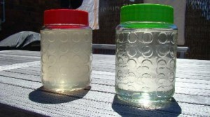
Under normal flow conditions, and after cleaning up the sewage discharge problems, it is expected that the water clarity in the Tamar Lake will be as clear as that in Trevallyn Lake.
Under normal conditions the water level will be maintained at between the current three-quarters and full high tide level, or about 0.3m below normal high tide.
In the current navigation channel at low tide, the navigation depth is typically 2 metres between Freshwater Point and the Yacht Basin.
The formation of the lake will provide a channel navigation depth of typically 5 metres, 24 hours per day.
With the level of the water in the lake being able to be varied with the spillway gates in the barrage, and with the ability to measure the current tidal water table, it will be possible to maintain the current level with the barrage in place.
To achieve this, we believe the lake level will be between 0.3m and 1.0 m below the current high tide level.
Further modelling will be required to be done to confirm this.
The water table will rise by the same amount with potential disastrous consequences for structures and roads in the low lying areas, particularly around Invermay and the CBD areas bordering the North Esk.
The rice grass will gradually die off and decompose in the fresh water environment.
With the freshwater suitable for irrigation available from any location, a Tamar Lake Irrigation Scheme will be developed with the potential for irrigation of farms on both sides of the lake from Rosevears/Dilston to Beauty Point/Hillwood.
Our studies indicate that on 1500 hectares of irrigated class 3 and class 4 land from a potential 15000 hectares of irrigable land, farmers could:
- Double the current area of vineyards;
- Greatly expand the the area of apple and pear orchards;
- Provide a major boost to the number of cherry farms and other stone fruit;
- Enable the expansion of area of berry fruit under cultivation.
The barrage has two ship locks installed in the wall to accommodate leisure craft and commercial vessels the size of the Wyuna and the Queenscliff ferries, and any ship that could use the ship-lift facility at Kings Wharf.
TasWater has provided a preliminary cost estimate of $200m to $220m,with completion within 5 to 10 years.
The environment impact assessments show that while there will be some displacement of natural ecological values (which will have to be managed), no listed species will be threatened and the freshwater habitats (including the Tamar Island Wetlands) will be greatly expanded.
The formation of the lake does increase the risk of the formation of extensive algal bloom problems or acidification, however, two programs that are currently in the early planning/implementation stages; the TasWater Launceston Sewage Improvement Project, and the NRM North TEER Water Quality Improvement Plan (WQIP) are both expected to have made major reductions in both diffuse and point sources of sediment, nutrients and bacteria entering the lake by the expected completion of the barrage in 2022, thus greatly reducing the risk of algal blooms.
This risk is also mitigated by the low water temperature of the cool temperate Tasmanian climate and the rate of flushing of the waters of the lake of at least 4 times per year due to the huge inflows from the catchment.
The Tamar Island Wetlands are already a freshwater habitat so there will be no change in water salinity. However, as some of the lagoons in the wetlands rely on tidal movements, the Tamar Lake project will need to ensure the lake water level is high enough to top up the wetlands during dry periods.
The Petitcodiac River at Moncton in Canada, has been used as an example of what may happen with the Tamar Lake proposal for a barrage across the Tamar River at Rowella.
In the case of the Petitcodiac River, (known colloquially as the Chocolate River), the situation is very different to the Tamar Estuary, in that the “barrage” (really a road causeway with narrow gates) is situated 40km upstream of the river mouth which enters into the Bay of Fundy, which has the highest tidal range in the world.
Before the barrage was built in 1968, twice a day a huge tidal surge swept upstream with what is known as a tidal bore, with wave fronts up to 2 metres high and a speed of 5 to 13 kilometres per hour. This tidal prism created a tidal range of up to 7.5m at the barrage site in Moncton, with the saltwater tide completely overwhelming the relatively low freshwater flows downstream from the river catchment, but ensuring a thorough mixing of the two flows.
After the barrage was built in 1968, the incoming tidal flows were truncated at the barrage and the huge volume of ocean silt carried on the incoming tide had nowhere to go but deposit in the area downstream of the barrage. The sedimentation deposits are principally coarse ocean silts mixed with fine particle alluvial silts carried downstream on the freshwater and flocculated out when the freshwater mixes with the saltwater.
With the barrage closed, the situation is analogous to the current Home Reach and Yacht Basin section of the Tamar in that the asymmetric flood tide carries flocculated silt upstream until it has nowhere to go but deposit out in the quiescent conditions. Unfortunately, Launceston does not have a barrage to remove or any other method to substantially increase the tidal prism as Professor Davis has been advocating.
In hindsight, clearly the barrage on the Petitcodiac River was a dumb move and the causeway and gates are now being removed and replaced with a bridge, allowing the full tidal prism to flow and erode some of the residual silt that has accumulated over the last 46 years.
In the Tamar Lake case, since its formation the members of Tamar Lake Inc , through their private donations, has sought quantification of the potential risk of serious silt deposition in the area below the barrage, but with the best 2D tools available in 2012, our scientific advisors gave us sufficient confidence that deposition would be minimal for Tamar Lake Inc to spend member’s funds for the subsequent environmental and economic studies that have been carried out.
However, recognising that this area could still be a potential showstopper, Tamar Lake Inc has been successful in gaining State and Federal Government funding, in partnership with the Launceston Flood Authority and NRM North to commission the construction of a 3D model of the Tamar which, with the application of this model to the whole Tamar Lake environment, will enable us to be confident of the potential for silt deposition below the barrage and proceed with full legislative planning for the project.
The results of these studies are expected by March 2015, and the community can be assured that if not as expected, the Tamar Lake members will lose interest in moving into the detailed planning phase.
Your question not answered in the section above?
Please submit your question in the form below with your name and email address, and we will respond promptly.