The general location of the barrage in the Rowella/Long Reach area has been determined by the strategic requirements of flood mitigation, silt transport and economic costs/benefits.
In this pre-feasibility/proof of concept stage the barrage located in the Long Reach area has been chosen as the preferred location, with social license, construction and operating access costs, and technical benefits.
Tamar Lake Inc has received letters of comfort for approval of the Long Reach site from the residents of Rowella, and construction access and right of way for a pedestrian/bicycle pathway from West Bay Road to East Tamar Highway from the owners of the land on each side of the Tamar at the barrage location.
If the project proceeds into the detailed planning process, then the cost/benefits of this site and any alternative sites, must be explored, before a final site is chosen.
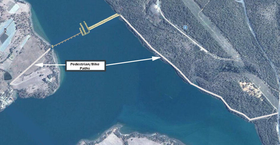
Tamar Barrage location in Long Reach
Preferred Barrage Site
Barrage Design
Construction Materials and cost
The barrage, located near the South end of the Long Reach section of the river, (see figure above), will be constructed with a concrete faced rock wall for the deep and non- operational section of the total 800 metre long barrage, with the 350 metre wide gate section and the two locks constructed of pre-formed concrete on the much shallower rock ledge section off the West shore.
The barrage design consultants, CDM Smith, have provided a preliminary cost estimate of $500m, with 75% of the labour and materials locally sourced, 20% from interstate, and 5 % internationally. This figure includes a 50% contingency cost factor.
Barrage Functions
The functions that the barrage must perform are:
- To provide a clear separation between the freshwater lake environment and the saltwater estuary environment.
- The ability to pass all normal and up to 200 year ARI flood flows without negatively affecting flood levels upstream in Launceston.
- The ability to block a future sea level rise of up to 0.8m.
- The ability to maintain a constant water level in the lake, but to operationally vary that water level from current mid to high tide level.
- The ability for small leisure craft and larger commercial vessels to transit the barrage via two locks.
- The ability for migrating fish and eels to transit the barrage for life cycle purposes.
Barrage Components
To achieve the above functions, the following components will be incorporated in the barrage design
Crest Level
Crest level of at least 2.2 metres AHD to block current tidal levels plus provision for a sea level rise of 0.8 metres.
Spillway Gates
Size
10 vertical lift gates each 35 metres wide by 5.2 metres high
Flood Safety Control
The flood analysis carried out by our consultants, BMT WBM, has shown that with normal operation of the gates, there will be no detrimental effect on flood levels in the valley south of the barrage or in Launceston, when compared with flood levels in the current tidal regime.
However, if for some reason the gates are unable to operate, the barrage presents as a weir with a crest at 2.2m AHD, in which case the flood levels in Launceston and the Valley could be increased by as much as 1.0m for a 200 year ARI flood event.
To prevent this from ever occurring, the barrage will be designed to be completely fail safe.
This will occur at two levels:
Redundancy/backup
The system has 10 independently operated gates, with a backup power supply from a diesel powered generator
Fail Safe
Under normal operation, each of the 10 gates will be constrained in the vertical plane by a shear pin or bolt. Should any or all of the gates fail to operate with rising flood waters, the water pressure will cause the shear pin/bolt to break and allow the gate to pivot on a horizontal plane about an axis at the bottom of the gate, allowing unconstrained flow down river to relieve potential flooding.
The design of this mechanism will be included in the detailed design of the barrage.
Locks
Barrage will be fitted with two locks for the passage of boats and small ships up and down the river. To reduce cycle time, the small lock will accommodate pleasure powerboats and yachts, with a larger, less frequently used lock for the commercial tugs, ferries, tourist boats etc. The small lock will be user operated with suitable security.
A preliminary estimate of the lock sizes are:
- Small lock – 40m long by 8m wide
- Large lock – 70m long by 18m wide
Footbridge/bike path
An elevated footbridge/bike path will be constructed on top of the wall; integrated into the vertical lift gate assembly; and mounted on top of the lock gates.
This will provide passage for pedestrians and cyclists from West Bay Road, Rowella, to the East Tamar Highway, except when a lock is in operation
Fish Ladders
Fish ladders, principally for the passage of eels and Australian Grayling will be incorporated in the wall.