Estuarine Barrage examples in other countries.
- Cardiff Bay Barrage, Wales
- Marina Barrage – Singapore
- Barrages on the Seine River – France
- Fitzroy River Barrage – Rockhampton, Queensland
In considering the installation of a barrage in the Tamar River to solve the silt accumulation problem in the upper reaches, and provide the foundations for a major boost to economic activity in Launceston and the Tamar Valley, it is important that we examine and learn from the history of other estuarine barrage systems around the world, and the effects on the environment and economic developments of the towns and cities through which the river system flows.
In the initial studies carried out by Tamar Lake Inc, we identified two barrage systems in other countries that, while having some effect on the environment, in balance stimulated a huge economic boost to commercial and tourist development of the area surrounding the lake formed behind the barrage.
These two examples were:
- Cardiff Bay Barrage in Wales, constructed in 1999
- Marina Bay Barrage in Singapore, constructed in 2008.
In both cases, the commercial development around the shores of the lakes has been extraordinary, and they have both become major tourist attractions in their own right, but both projects have also involved parallel development of measures to manage flooding of the banks of the lakes, and to maximise water quality through the minimisation of pollutants from diffuse and point sources of sediments, nutrients and bacteria flowing into the lake from the catchments and urban runoff.
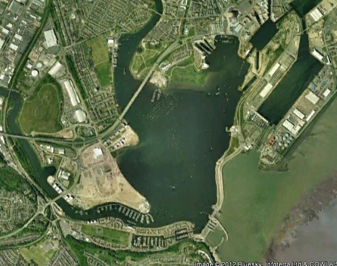
Cardiff Bay Barrage.
Background
Cardiff has the second largest tidal range in the world of 9 to 14 metres, and has two rivers, the Taff and the Ely, discharging their silt laden freshwater into the Bay. Prior to the construction of the barrage, the Bay emptied twice each day exposing extensive mud flats, and severely limiting commercial and private navigation into and out of the harbour.
In 1999 the construction of a barrage across the entrance to the Bay was completed forming a freshwater lake of 2km2 in area.
The completion of the barrage has stimulated the re-generation of the previously run down industrial area with attractions such as the Wales Millennium Centre, the National Assembly for Wales, shopping centres and parklands. The lake has now become a major facility for all water sports and a safe haven for yachting and pleasure boat activity.
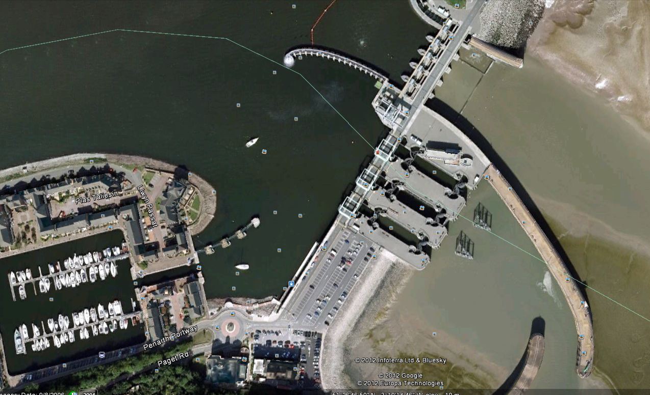
Cardiff Bay Cardiff Barrage
Technical
The barrage spans a total distance of 1.2kms across the entrance to the Bay, with 900m being rock and sand filled embankment and 300m for locks and sluice gates. It cost approx. £200m to construct.
The following materials were used in the barrage construction:
Concrete – 135,000m3
Rock armour – 250,000m3
Sand – 1,700,000m3
The structure has 3 locks each 40 metres long with two 8 metres wide and one 10.5metres wide.
As the estuary has a high tidal range, the lock gates are up to 16m high to enable boats to pass through at all stages of the tide.
In addition to the locks, there are five sluice gates 9 metres wide and 7.5 metres high which control the level of the water in the Bay.
In addition to providing a barrier to prevent seawater entering the bay, the gates are used to mitigate the effect of flood waters flowing down the Taff and Ely Rivers.
A fish pass is provided for migrating fish.
Marina Barrage – Singapore
Background
The Marina Barrage in Singapore was constructed in 2008 across the entrance to Marina Bay and Kallang Basin to form a large freshwater reservoir in the financial area of the city with limited access to marine transportation.
Freshwater into Marina Bay is fed via two rivers from a catchment area of approx. 20% of Singapore Island,
As well as being a source of freshwater supply to the city, the barrage acts as a tidal barrier to keep seawater out and alleviates flooding in low-lying areas such as Chinatown and Little India.
The formation of the constant level Marina Lake has provided a major boost to commercial and industrial development around the shores, as well as becoming a major focus for water sports and cultural activities.
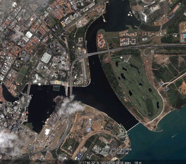
Singapore Bay with marina in place
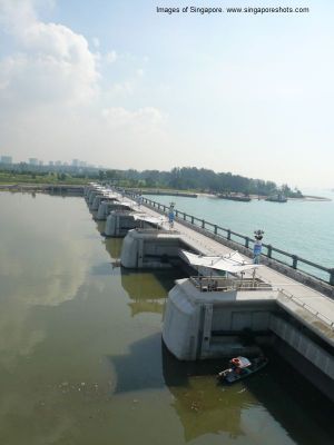
Marina Barrage gates and footbridge
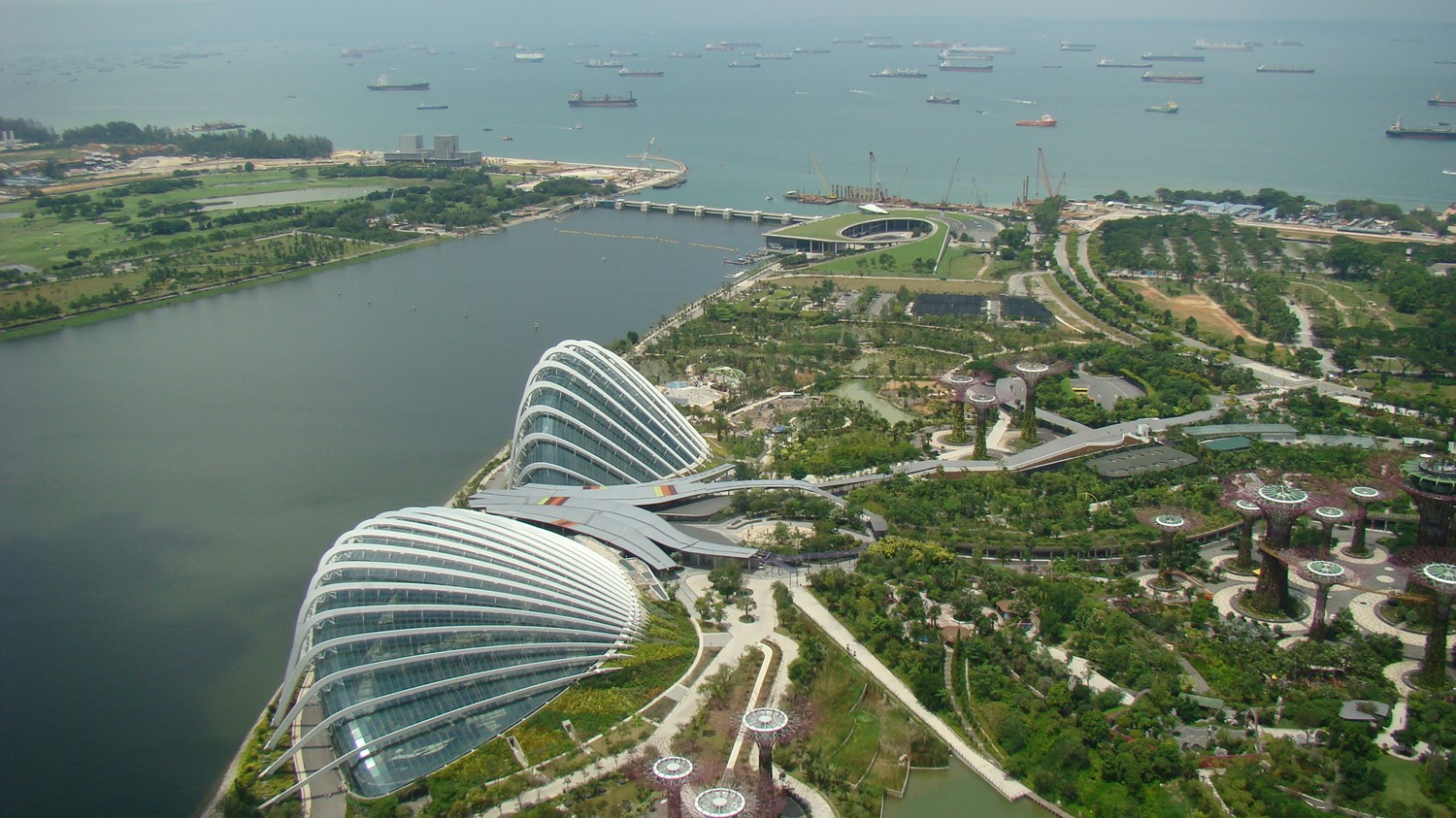
Singapore Barrage Perspective
Technical
The Marina Barrage spans 350 metres across the entrance to the Bay with nine, 30 metre wide and 5 metre high crest gates which operate together with seven pumps to maintain a constant water level in the lake and provide mitigation of the risk of flood.
The pumps have a combined capacity of 280m3/sec and are used when a flood threat event and high tide event coincide to limit flow through the gates. To provide for the passage of boats from and to the lake, a ship lift is provided to handle boats up to 20 metres in length, 6 metres wide and weighing up to 70 tonnes. Cost of the construction of the barrage in 2008 was A$170m.
The Seine: A 370km long clean/green silt free waterway from Paris to the English Channel at Honfleur.
If any further convincing that a clean/green silt free Tamar is achievable was needed, a 6 night river cruise on a 75 cabin/150 passenger cruise liner from the centre of Paris to the Seine estuary entrance at Honfleur, has confirmed my views.
With climate and rainfall conditions very similar to Northern Tasmania, and average river flows about the same as the South Esk, today the 760km long Seine presents as a clean, wide, deep (9 to 10 metres) highly trafficked waterway the 370 km from the Eifel Tower to the English Channel. It is the source of drinking and industrial freshwater for the developed areas of Paris and other cities and towns on the river, and agricultural irrigation for the extensive farmlands in the greater Seine Basin.
However, this has not always been the case. It was only 40 years ago that the Seine River was declared “dead”. Levels of pollution from industry and agriculture were dangerously high; native fish had disappeared; plant life was dying and the water was unsafe for swimming. (Is this familiar?).
Today, the city of Paris organises fishing contests and swimming races in the Seine on summer afternoons.
Burdened and supported by a population of 17 million in the Seine Normandy Basin, an extensive development of point source sewage treatment infrastructure and an on-going program of farm management practice improvement has cleaned up the Seine.
From a navigation and freshwater supply viewpoint, the river has been segmented into a tidal estuary that allows ocean going container and bulk freight ships to load and discharge their cargoes at the port of Rouen, 120 kms upstream from the mouth; and a series of 6 freshwater lakes with a total of 7 barrage/lock combinations between Rouen and Paris that not only provides a secure supply of freshwater for domestic and agricultural applications, but also a constant navigation channel depth for freight barges and river cruise liners all the way to Paris.
Much of the credit for the improvement in the health and amenity of the river has been given to the administrative decision in 1964 to form six river management authorities to be responsible for each of the six natural hydrographic lake units formed by the barrages. The average size of each lake unit is 40kms, about the same length as Tamar Lake.
Before the installation of the first barrage in the late 1800s, the river in Paris consisted of a small, shallow channel of continuous flow, bordered by sandy banks. Today, despite the low average flow, the depth of the lake is tightly controlled at 9.5 metres, and the entire width of the river between the built-up banks is normally filled with water.
The water level in Paris is 24 metres above sea level, with each of the seven barrages dropping the lake levels by 3 to 4 metres. The same maximum drop as the single barrage forming the proposed Tamar Lake.
From a tourist viewpoint, the entire waterway is a clean, low turbidity passage with no sign of silt accumulation on the sand and gravel banks until the estuary mouth, where the very large tide of 7 to 10 metres with storm surges even higher is posing a problem for the authorities with huge volumes of coarse sand forcing its way a short distance up the estuary and tending to block the passageway into the English Channel.
Fitzroy River Barrage – Queensland
The Fitzroy River Barrage is the major storage in the Region. The Barrage is the water source for the town of Rockhampton and surrounding areas of Gracemere, The Caves and Nerimbera in addition to supplying agriculture water to approximately 240 rural users.
The Fitzroy Barrage and the Glenmore Water Treatment Plant were constructed in 1971 to meet the long-term water supply needs of Rockhampton. The Barrage separates the fresh water upstream from the tidal salt water downstream and has a storage volume of 81,300 megalitres (of which approximately 21,900 megalitres is dead storage or water that is not available for use or diversion).
If water allocations are drawn from the Barrage at the maximum approved amounts, the Barrage will hold sufficient water to supply the Rockhampton area for nine months without any run-off in to the river over its vast catchment.
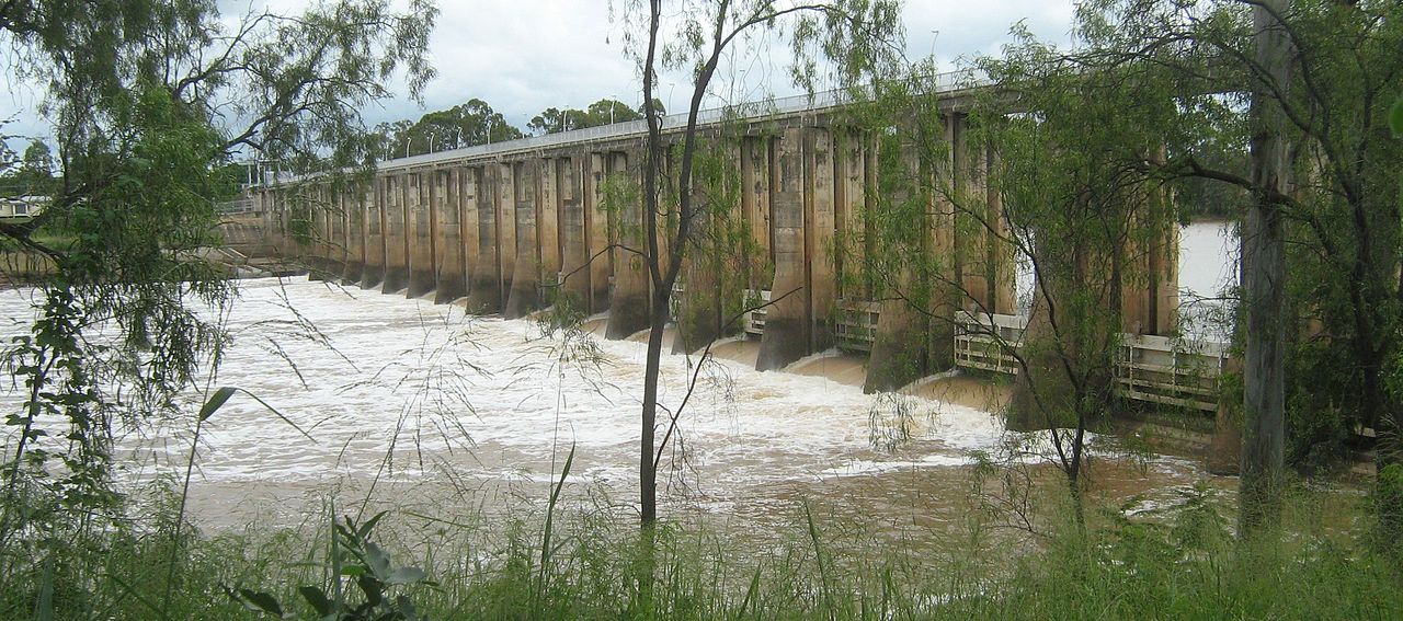
Rockhampton Barrage
Rockhampton Regional Council is the Resource Operations Licence Holder for the Barrage and is required to operate the storage in accordance with the requirements of the Fitzroy Resource Operations Plan. This requires water releases to be made at certain times to meet environmental flow requirements (including operation of the fish ladder).
Monitoring of water quality, including blue green algae, and management of certain issues regarding medium priority water allocation holders (mainly irrigators) is also required. Fresh water is separated from salt water by 18 vertical lift gates on the Barrage which are remotely controlled and monitored by a computer system.
The Barrage was constructed with liftable gates to keep the upstream river levels as close as practical to full supply level to prevent the river level rising above its natural flood levels and operation of the gates is carried out automatically in response to rises in river height.
A fish ladder operates at the southern bank of the River when the water level is within 600mm of full supply level and it is estimated that well over 500,000 fish successfully negotiate the fish way each year.